The present study draws attention to cartographic technologies as the privileged research field where geography is called upon to meet the challenges of globalization. As a matter of fact, researchers in the field have long matured the conviction that cartographic representation is tightly linked to territory and therefore a rendering of contemporary spatiality necessarily entails skills both in territorial analysis and in cartographic semiology. In modern times, topographic metrics, inherited from Euclidean cartography, had severed the link between geography and cartography. Maps were merely intended to render the referential or quantitative features of territory. Nowadays, instead, having eluded controls of the institutional kind, maps are intended both by territorial analysts and by the various agents involved in emerging online scenarios, as representations capable of conveying the social meaning of territory. Notably, new cartographic technologies prove it necessary to consider two perspectives: the epistemic one, whereby we look at the role maps play nowadays in imparting territorial information; and the experimental one, meant to produce new maps that might meet the needs of a new definition of spatiality and thereby reclaim the issues of social groups who demand direct participation in the decision making linked to the challenge of globalization. The present study outlines theoretical issues touching upon the latter perspective, with methodological examples taken from a number of products assembled at the Diathesis Cartographic Laboratory of Bergamo University [1].
Globalization and cartographic technologies.
The innovative features envisioned by contemporary cartography have been made possible by the emergence of cybernetics: they entail a multiplication of cartographic typologies and an increase in the number of places where maps are produced. Both new trends can be explained in view of the social change that has taken place in two specific realms: the political realm of democratization inherent in governance; and the institutional one, marked by the adoption of geography-based IT in relations with citizens. As a matter of fact, the scene where democratization policies are implemented is also, among many other features, closely tied to the new decision-making process that states are expected to follow in the context of globalization. Having lost its exclusive role as a political agent, the state has in fact been partnered with other subjects, who come from a new form of citizenship altogether different from the one where birth dictates affiliation to a national territory. We are dealing with the so-called “mobility citizenship”, centred upon values that reflect the functioning of an online world, where mobility and multiple relations, brought about by the collapse of boundaries, make up the identifying scenario where a given subject—a citizen–belongs [2]. The redefinition of citizenship has expanded and diversified the number of political agents who want and can have a voice in social issues, not the least in issues related to the environment and territory. New sites of territorial and environmental planning have therefore been set up, where the presence of new “citizens” rests on their awareness of being able to affect decisions: not only through the modes of indirect representation or the usual electoral systems, but also through forms of direct participation [3].
The first outcome of this new way of approaching politics has been an inescapable search for consensus, achieved by widening participation in decision-making processes that involve both large-scale issues of globalization and small-scale management of local territories. The creation of consultation tables, at first the results of grass-roots initiatives, has —within the increasing complexity of political scenarios— drawn the attention of international organizations. We have thus come to define the principle of governance, whereby decision-making on issues of public interest engages both public institutions and private companies with actively participating local communities. Such principle, by now an inevitable aspect of democratic decision-making, nowadays stands as a privileged testing field for finding tools that may adequately promote dialogue in the management of public matters. In fact, what is systematically pointed out in discourses on governance is the fact that standard modes of the decision-making process have utterly lost their legitimacy or effectiveness. It has become necessary to supply a set of tools aimed at enforcing the principles of openness and sharing, such as information technologies (It), now largely adopted in most administrative structures to cope with the complexity of contemporary issues. Its are acknowledged to have a number of public and social advantages: improvement in social practices; decision-making optimization; facilitation of communication processes; advancement in the actual exercise of local democracy.
It is in this context that cartography stands out, in its strategic role as a form of representation aimed at consensus. And the technologies of geographic information (Git) are in fact a specific subset of It, since they rely on the same technical infrastructures and use the same communication networks, i.e. internet, intranet, and so forth. To be more precise, Git imply two types of usage: they are meant on the one hand to gather, to cull, and to manage geographical data; on the other, to analyse, formalise, and visualise such data in graphical or cartographical form. Their scope is wide and embraces all the sectors dealing with territory management (town planning, territory survey and diagnostics, network and infrastructure management, land management, transportation, and so on) and environmental planning (environmental protection and conservation, local development, promotion of protection policies). In time, Gits have come to dominate the practices of designing, planning, and management of territory at all levels of administration (international, national, regional, local, urban, and rural). They engage ever-wider and ever more varied issues (development, economics, natural resource management, territorial marketing, crisis management, public health, town planning, etc.) [4]
To be sure, there have been critics of information technology on the social level. In their view, information technology systems deserve recognition for ensuring wide and open access to a large quantity of territorial data, and for making these easily available even to inexperienced users. On the other hand, critics point out two aspects that somehow create a gap between Gits and local participants: 1) Gits may either marginalize or consolidate a few specific social groups, since such tools are only accessible to a small part of the world, the one which has the means and the tools to buy and update expensive software; 2) and Gits may in fact cause a rift between representation and actual territory, for they entail cartographical representations that are granted objective status and are then used to lay down and to carry out territorial interventions. Ultimately, Information Technology Systems may lead to a consideration of local communities —charted by data— as “the others”. The other is essentially seen as “existing in Cartesian space … while the person doing the judgement remains centred in the human world” [5]. What critics point to is not much the poorly democratic character of Gits, but rather their disturbing potential as symbols that convey a biased worldview: a supposedly objective interface between society and reality that is in fact designed along the prescriptions of those who are endowed with privileged technical know-how [6].
Starting in the mid-1990s, criticism of this kind has been met with a renewed attention to creating cartographic systems able to reclaim the role of local communities in the process of cartographic production. The aim is to carry out planning interventions on the basis of cartographical representations that are able to take local interests into account. This is what is meant by participatory cartographic systems. Depending on the type of technology involved and on the level of participation, they comprise: 1) participatory cartography, produced by local communities upon request of an external agent. [7]; 2) Gis systems, comprising in turn Cigis (Community Integrated Gis), that are built and used by agents outside the local communities but also feature data gathered through participatory methods [8]; 3) and Ppgis (Public Participation Gis) built and used directly by local communities in their interpersonal dialogue with their own administrations or their own supervising institutions [9].
We will presently come back to participatory cartography and Cigis, since they make up the field where testing has been carried out. We will not cover technical issues related to Gis participation (WebGis, Ppgis, i.e. Web2.0 related cartography) for these are beyond the scope of the present study. Let us first, however, consider the theoretical bases on which these systems are built.
From topographic metrics to reflexive cartography.
The notion of a reflexive cartography, able to render the social values of a specific territory, relies on clear building strategies, with a view to producing maps within “enunciatory conditions” that state specific objectives and enable the addressee to exercise their own critical skills. We should not forget that, from a communicative standpoint, the iconizing effect of a map, i.e. its ability to impose its own specific and peculiar view of the world, may be effective only if taken loosely, as a tool presumably capable of rendering phenomena as objective data [10]. If however one states that phenomena are being analysed only in part and seen through a particular viewpoint, one obviously limits the map’s self-referentiality as well as its iconizing thrust. By renouncing the myth of a descriptive map, whose authority depends on its presumed objectivity, one steps into the realm of maps whose messages are instead inescapably tied up to a project that has been made clearly explicit [11].
Let us now consider the theoretical framework we need in order to pursue this type of cartography and look at some of the assumptions, or semiotic threads of its fabric: 1) a metrics able to render a relational spatiality; 2) the typology of data gathered from the various agents attending the site of representation; 3) and lastly, the graphical rendering of data, whose aim should be to achieve actual participation and thus enforce governance.
Since we adopt a semiotic perspective to ground our practical proposal for the construction of a map, we should keep in mind that our primary aim is to reclaim the social dimension of territory. To achieve this, we will operate on two different levels: 1) we will reject two-dimensional Euclidean space, and embrace new horizons that reinstate a third dimension; by doing this we will be giving up criteria based on an exclusive viewpoint, on metrical accuracy or on linear distance in favour of new criteria of subjectivity, relativity, and relational distance that belong to topological space; 2) consequently, phenomena will not be made to correspond to abstract icons based on positivistic assumptions, but will be seen as socially produced values, be they material or symbolical, to be signalled by icons whose figural potential has been duly reappraised.
As to the first point, the fact that we assume a topological space in cartography makes for a number of advantages, both operational and content-related. Such space is in fact open to multiple metrics, and thus the map’s layout may match a number of different reduction scales. Also, distance may be measured in relation to criteria other than metrical (such as time or cost, or other), with an eye on the importance of the phenomena being mapped. By renouncing the uniformity principle featured in Euclidean space, the multiple-scale model produces a discontinuity threshold in distance computation that inevitably affects our evaluation of phenomena, and opens up new interpretive perspectives. If, in fact, social metrics is defined with reference to relational distance, we must define the value of such distance by tweaking the use of scales, which vary in accordance with the value each phenomenon is assigned [12]. Therefore, scale comes to represent the discontinuity threshold both in the measurement of distance and in the appraisal of phenomena.
If we assess the types of data to be collected, we are faced with the need to design maps that are not exclusively limited to rendering data based on the territory’s visual setup; we need maps able to reclaim information related to the territory’s values, the only ones that can properly record the meaning of the place being mapped. Topography has long stood by the notion that, in order to understand the space of individuals, it was necessary and it was sufficient to concern oneself with a set of spatial attributes grounded in topographic metrics. Now, on the other hand, one needs to take into account the interests of individuals who socialise and express themselves through landscape, seen as a public space, a forum where opinions are exchanged and personal values shared [13]. Practically speaking, we would need to be able to record the meaning individuals assign to landscape as a visual analogue of territory, since territory reflects the values, the beliefs, and the knowledge that, as a local community, individuals have entrusted to it over time [14]. That would allow us to show the degree to which topographic and social spatiality differ.
To enforce this perspective we need first to give up our claims to exhaustiveness, but also, and most importantly, our notion of cartographic information as uniquely accurate. And of course we must make our objective explicit: we do not set out to map landscape as an absolute value in itself, but rather intend to record it as a set of shared values, coming from a specific cultural context, and aimed at supporting specific interests and a specific viewpoint. It is by now largely granted that the notion of landscape demarcates an arena of exchange between subjects who point out and highlight the knowledge they have acquired in time though their daily contact with nature. And that is the knowledge that has eventually been reflected in the landscape itself. What is ultimately foregrounded is the dynamic setup of landscape; a product of spatial and temporal relations between nature and society caught in endless fluctuation and shift. We should be aiming at a kind of landscape cartography that does not rely on the foundational values of a given society but sets out to identify what has been sedimented, multiplied, or otherwise lost in time with regard to the stakes a given community has put up in order to ensure its survival and its social reproduction. Ultimately, identity ought to be seen as an identitarian discourse: the whole set of cultural roots and social values produced by territorial interventions and later signified and iconized through landscape [15].
To be sure, such cartographic perspective requires primarily a territorial research method able to reclaim the landscape values produced by social agents. We need to proceed by collecting terrain data capable of recording the relevance such values have within local communities. In fact, it should not be forgotten that if landscape stands for a specification of territory, the latter is the product of the communities who have acted upon it and it is the condition that makes it possible for them to exist. More importantly, it is the representation that conveys these communities and grants them visibility.
From a practical standpoint, we simply cannot ignore the need to reclaim the territorial dynamics of local communities, for those make it possible for us to gather data on landscape from an analysis of habitation using the Sigap strategy [16]. Sigap is a research method that takes care of the whole mapping process. It produces participatory tools based on the use of Git (participatory maps, Cigis, WebGis) with a view to providing a participatory management plan of territory. It sets two main goals:
1) to reclaim the territory’s layout and landscape values in accordance with local communities and the value systems that inform their practices;
2) to produce a participatory cartography functioning as a symbolic operator able to convey the social meaning of territory on a double scale (local and regional) [17].
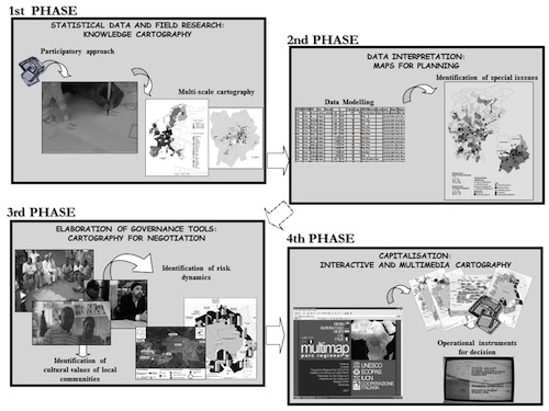 Figure 1 – Modular phases of the Sigap strategy (E. Casti, 2010).
Such strategy, built on modular phases (Fig. 1), relies on participatory notion of terrain research, which involves multiple agents and thus rehabilitates the subject in its essential role. What is reclaimed is the subjectivity of several individuals, expressed in a shared sentiment that is rooted in socially constructed skills and know-hows. Concurrently, by virtue of its direct investment in IT, such strategy entails the disruption of traditional cartographic assumptions: the objectivity of maps is questioned and maps are opened up to a whole range of creative directions made possible by a relativistic informational approach. Let us consider a few practical instances of this methodology.
Cartographic experiments: African villages and Italian towns.
The two territorial fields we have chosen in order to exemplify a cartographic approach to governance —Africa and Italy— present antithetical territorial and political setups, which should help test the applicability of the Sigap strategy across very different contexts. Africa features mainly village communities grounded on traditionally strong charters that organize and regulate local communities. Africa’s current setup is the result of a colonial past that produced an internal rift between state-enforced law and legitimate local systems never acknowledged as territorial structures [18]. Such rift is still very much observable in many African states across vast regions, especially in the Sub-Saharan area. It provides an excellent testing ground for the effectiveness of participatory systems in reclaiming the territorial legitimacy of local communities. Italy, on the other hand, offers an intriguing case study by virtue of its scattered urban system, in many respects fully at variance with Africa, and yet increasingly similar to its setup in a recent developments. Italy’s unification in fact occurred with the adoption of a political and administrative framework which made legality and legitimacy coincide within one national unit. Yet, through globalization, that model is being nowadays progressively undermined by new citizens, who call for an acknowledgement of legitimacy within a newly formed society: a culturally and ethnically composite society not yet provided for in the homogenizing national system.
We are now going to provide examples of the cartographic technologies we have applied to two different contexts: the land-driven unrest within the Mahadaga village territorial province and the net-like phenomenon of Chinese immigration in Italy as exemplified in the Sarpi district in Milan.
Land-driven unrest within the territorial province of the Mahadaga village (Burkina Faso).
The village of Mahadaga, located in the area between the Gobnangou cliff and the protected area of the Arly Park in Eastern Burkinabè, is a major political structure within the traditional statute of the Gourmantché, a historically predominant ethnic group in the region [19]. It is a mother village which breeds (and/or grants) another 24 settlements (21 villages + 3 Peul camps) within its territory. All of these acknowledge the authority of the village chief (bado) over land issues and other crucial survival matters [20].
It became obvious from the very first phases of research that the persistence of a traditional setup within that area had good potential, since that setup can effectively function as a leading structure in the changes brought about by exogenous issues. It was therefore decided to evaluate the solidity of that setup in the face of conflict triggered by competition in the use of land; and to focus all efforts toward building a participatory cartography able to account for the stakes, the agents involved, and the land pressure.
Data related to conflict were gathered by drawing up participatory maps and Cigis, whose preparation, envisaged in the planning stage, contributed to a full outline of issues and participatory tools to be used at consultation tables and in our exchange with the village authorities. We made it clear that the method we employed in our research entailed various phases, in the course of which participatory cartography served as a support tool for charting phenomena and for interpreting them. In the final phase, involving a graphical representation, we allowed for the multiple agents involved and for their need to see their interests represented. Thus, in drawing up a map of the Mahadaga village, former conventions were abandoned to test new graphical solutions that would outline the stakes as well as their relevance to a common, shared location (Fig. 2).
Figure 2 – The Mahadaga village (E. Casti, 2010).
The map outlines the distribution of villages and of farming within the diema where crop allotment was quantified. The central unit of the Mahadaga village shows exclusive cereal farming and the absence of conflict. On the other hand, cotton farming is practised outside, within the former conservation zone, and its quantified total hovers in excess of 60% of agricultural production. This is the zone where conflicts tend to concentrate: 1) between generations; 2) between agricultural farmers and breeders as a result of demographic pressure and of cotton crop expansion; and 3) between agricultural and transhumant farmers on account of the contiguity between their areas and the conservation area over issues of land occupation.
Since we were expected to use such data at consultation tables, we adopted figural language and a landscape perspective: the cliff, which shuts off the horizon, is displayed graphically. Main concessions within the core village unit are signalled by a standard figural icon whose dimensions vary, however, in accordance with the social role they occupy (for instance, the icon for the village chief’s–Bardiegu–is large). These icons are also colour-coded with reference to the lineage of inhabitants and their respective degree of power. Conversely, exogenous territorial features (cotton markets, schools, churches, dispensaries) are recorded by unique but, once again, figural icons. Even reduction scales used on the map differ with regard to the social relevance assigned to the territory. The central core, the seat of political, religious, and landed authority, is displayed at a larger scale than the rest, so that the distribution of cereal farming areas may be properly highlighted. The reservation zone, scattered with villages and camps, is instead substantially scaled down, and settlements are therefore simply marked by designators and quantitative data, as percentages of the types of farming each village possesses. Information of this kind is charted through aerograms, which enables consultation members to compare and contrast the percent incidence of each village on coastal land. Crucial sites of the conflicts and the agents therein involved were also charted (Fig. 3).
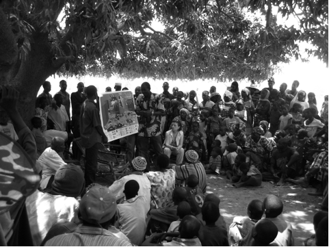 Figure 3 – Identifying conflicts through participatory methods (E. Casti, 2010).
The map was therefore offered as a tool displaying basic data in which talks ought to be grounded. To be more precise: the identification of agents and their respective interests has forced the parties involved to cope with issues from a unified perspective. The quantification and qualification of crop distribution has allowed them to ascribe responsibilities to specific villages, which in turn paves the way to a redistribution of usage rights on traditional bases. And the solutions proposed with reference to external agents, such as transhumant farmers or Park managers, has given proof of the administrators’ commitment to sharing responsibilities and providing support with regard to the existing landed system.
We might conclude by noting that, in the case of Mahadaga, we were given the chance to verify the effectiveness of our cartographic tools: to ascertain its viability, as well as its contributing force in possible solutions to existing conflicts.
The net-like quality of Chinese immigration in Italy: the Sarpi district in Milan.
The question we endeavoured to address in Italy, i.e. Chinese immigration in Milan, features an urban territory woven into the net-like spatiality brought about by globalization. Apart from a quantitative or qualitative recording of Chinese immigration, what featured prominently in our cartographic mapping was the centrality of the trade chain not simply as an economic factor but as cultural model that informs the whole diasporic community engaging in territorial interventions [21]. Cities are, of course, the main junctures of this trade chain, where new districts and aggregation centres are born. And yet we thought it necessary from the start not to carry out a dot by-dot analysis, but rather chart networks in terms of their multiple-scale interrelations. As a matter of fact, multiscalarity established itself as an essential analytical option, and made it possible to think of participation as a way of identifying the viewpoints of the various agents involved at different scales. Hence the aim to foreground the kind of territorial legitimacy to be located within what we defined as “mobility citizenship”. The identification of area contexts, no matter how hazy, enabled us to ground research in a sort of trans-scalar hierarchy (national, regional, provincial) of nodes within the trade chain, which in turn yielded contextual data for an appraisal of the Milan example, i.e. the Sarpi district [22].
This analytical perspective was made first to cope with the difficulty of charting multiscalarity within such a vast territory through the construction of a single map. We therefore decided to take advantage of the potential offered by IT and set out to construct a representation where multiscalarity is made possible through real-time, software-driven interaction. This resulted in the construction of a Cigis (freely accessible online) that combines several maps drawn at different scales in order to render different information details while preserving overall unity. We publish a reproduction of the Cigis in this study with the sole intent of providing a graphical simulation of multiscalarity (Fig. 4) [23].
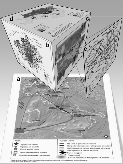 Figure 4 – Cigis of Chinese immigration in Italy (E. Casti, 2010).
As for processed data, it must be kept in mind that they were gathered from diverse sources. Quantitative data were provided by local institutions (Council, Chamber of Commerce, and the Milan Province), while qualitative data were collected through field analysis and research aimed at creating two participatory maps.
The first (Fig. 4a) emphasizes the hierarchical network of the production-marketing-distribution chain in Chinese trade in Italy. Also, it foregrounds the pervasively net-like set of operations proceeding from landing ports to production centres and distribution chains, operations that inevitably involve large areas of high-frequency regional activity and combine into one consistent whole the goods manufactured in Italy with those coming from China. Such chain does not simply affect the territory of Italy but is radially projected all across Europe. By virtue of systematic planning, Chinese traders have reached a level of maturity that has effectively shattered the boundaries of economic marginalization to a limited range of sectors and has promoted the flourishing of unprecedented entrepreneurship [24]. At the same time, Chinese entrepreneurship is at the centre of an unprecedented reclaiming of sites not previously envisioned as strategic trade junctures: as a result, the very territorial system of Italy is being reshaped. It can safely be stated that Chinese immigration in Italy differs from other nations by virtue of the outstanding entrepreneurial activities it has produced: a large number of businesses that have gradually been transforming territory and altering its original functions.
Yet, Milan’s strategic relevance in the context of national immigration is to be traced back to its social rather than its economic role. Having become a second or third-generation Chinese city, Milan owes its powerful appeal to having set up within itself the unfittingly-named « Chinatown » quarter, i.e. the Sarpi district. (Fig. 4e) [25]. Within the multi-faceted and many-sided phenomenon of Chinese immigration in Italy, the Sarpi district marks an important centre of attraction to all Chinese immigrants not only in Milan but across northern Italy also. Moreover, it functions as an essential stop for any Chinese tourist coming from the motherland. The migrating identity is embodied in the appropriation of a district: not only has it effectively overlapped the existing native population; it has also become rooted to a physical space, named with the term tángrénjiē, which in Chinese tradition signifies a place materially transformed and shaped on the basis of daily needs. The role played by the Sarpi district is enduring the test of time precisely because it has become the tángrénjiē of Chinese immigrants in Italy. It will be most difficult to change its value or its function as long as migrants continue to perceive it as the one and only public space for Chinese people.
Sarpi is not the only Chinese district in Milan, but it is the only one that plays this role of public space. Data collected by the Milan council clearly show that Sarpi is certainly not the most important Chinese residential district in the city: Chinese residents are scattered all over the city but tend to live predominantly in the districts of the ninth, the eighth, and the second constituencies (in descending order), i.e. in the northern part of Milan. This has produced a sort of functional gap between urban zones: The Sarpi district plays the role of public space grounded in trade, while jealously guarded places of residence, set aside for the privacy of one’s family, are scattered throughout the fabric of the city. This confirms the net-like spatiality of the Chinese diaspora, which strengthens its own identitarian sense of belonging by rooting itself not so much to the place of residence but to the relational space that trade, a type of remote relationship envisioned by globalization, is meant to preserve.
These are territories that uphold their legitimate right to be considered different; spaces that demand attention on the part of administrators who must be ready and willing to plan urban management in participatory and shared terms. In this context, it becomes essential to single out agents for consultation tables. As a matter of fact, urban governance envisions three crucial goals: 1) integration of social groups, agents, and separate interests into a common strategy; 2) effective reporting of such strategy to all external, institutional agents; and 3) identification of territorial features in their territorial, rather than local, relevance. Hence the critical importance of the territorial system and of multiterritoriality, usually conveyed–as in the case we outlined above–through what has been named a local system. Cohesion within that system is ensured by a shared value system: common modes of thinking and acting on the part of the subjects who make it up. Ultimately, the immigrant’s community is not a uniform cluster of people playing the same roles and taking on the same responsibilities toward the receiving country. Rather, it is a hierarchically structured community, where a few subjects play authoritative roles because they express shared collective values. Among ethnic networks established in Italy by Chinese immigrants, one for instance plays an outstanding role: it is the (xie hui) association, where fellow countrymen involved in urban planning act as competent mediators who may contribute to the creation of a multicultural society [26]. In that context, the Cigis we presented here is intended as a tool for negotiation and consultation.
Towards a “Chorography”.
In the present study, we have provided examples of cartographic testing aimed at conveying the social features of territory. And in the process we have come across a few issues, involving mainly data collection, data rendering, and the shortcomings of It tools currently in use. The role assigned to cartography within the Sigap strategy has demonstrated a new methodology for data collection, whereby data were not gathered in order to build a map but to unveil underlying issues. A map was then built with an eye to conveying the viewpoints of local communities. And choosing this field has de facto turned usual cartographic criteria upside down: data collection was not aimed at building a map. Rather, the map was meant to set data collection in motion and ensure its viability. Having opted for a cartographic rendering of data free from topographic rules and conventions has enabled us to multiply scales, to introduce a three-dimensional perspective and the use of icons and of other visual aids that call for an analysis of net-like spatiality. Each cartographic product has been offered as a representation, not to be equated to topographic maps, as in the Mahadaga case; and not comparable to the kind of conventional maps which, in their dynamic layering, effectively become “other”, as in the case of the Sarpi district. It must be forcefully stated that we are dealing with experimental mapping, whose form is at this time ill-suited to convey a social sense of territory and yet opens up promising prospects for further testing, stronger commitment, and keener insight.
What, however, experimentation has successfully established is that, as a tool for registering reality, cartography cannot possibly be removed from a study of the territory it sets out to represent. Experimentation attests to the symbiosis between geography and cartography, whose combined aim is clearly enhanced by the potential of It: to establish itself as a tool for structuring research as well as a communicative means that reclaims the potential inherent in territorial analysis. Cartographic technologies thus reintroduce cartography to show how territorial analysis ought not to be detached from its representation. In its turn, cartography endows geography with a new, central role within social studies: to investigate spatiality in the contemporary world.
