Intercultural Dialogue is one of the most pressing challenges of today’s plural world. Exchange and knowledge sharing among different cultures have been recently defined in the White Paper for Intercultural Dialogue “an antidote to violence and rejection” (Council of Europe, 2008). This work presents the result of research carried out in recent years by the Diathesis Cartographic Laboratory, which aimed to create a community mapping system able to communicate the social sense of place among communities living in a variety of territories [1]. In this context, based on the theoretical approach of cartographic semiosis (Casti, 1998a) and in line with the methodology of the SIGAP Strategy (Casti, 2004, 2006) we attempted to translate and implement some international principles regarding environmental protection and sustainability, using community mapping as the key tool in the various phases of research: from research to design, implementation and, finally, capitalization.
In this paper, we focus on the methodologies followed in a particular territorial context—the villages of Sub-Saharan Africa—with a specific aim: to create cartographic instruments capable of implementing the principles of environmental governance and sustainability within projects for cooperation.
This context offered the possibility of promoting, through the use of cartography, inter-cultural dialogue between parties from a variety of cultural contexts, each with their own specific interests [2]. This also allowed examination of cartography produced through environmental cooperation projects, from a reflective point of view. The aim was to provide the project with knowledge and intervention based cartographic systems that show territory in all its complexity, recording a variety of viewpoints, including the often-overlooked view of the inhabitants. In this way, the latter were supported to become the genuine promoters of the conservation action [3].
This is where a particular type of cartography comes into its own; participatory mapping [4], which merits some specific clarification. As in any territorial planning activity, including environmental contexts, cartography is an operative tool which influences decision-making [5]. In sub-Saharan Africa, as in other developing areas, it has been included in almost all environmental cooperation projects for several years. With this type of mapping, participation is often only justified formally, in so far as the importance commonly given to it nullifies, in practice, the role it can play in developing awareness and cultural values of the area of the local community [6].
Cartography and development cooperation projects.
Mapping became one of the participatory methodologies (Pms) [7] during the 1980’s [8], and became one of the tools used by agencies, Ngos, and local bodies during field research aimed at promoting development projects through involving rural communities in southern areas of the world. From then on, it has taken a variety of roles and forms, becoming the most common of the Pm tools [9].
Participatory mapping has entered into the range of investigative tools (transects [10], calendars, quantification tools, Venn diagrams, conflict matrices, role play, type analyses), giving it a specific purpose: the collection of territorial reference information, above all during the initial phases of research, which aims to supply an overview of the area under study, the natural resources, and the infrastructure present.
Towards the end of the 1980’s, with the rise of geographical information systems (including Gis and Gps) together with the optimisation of remote aerial and satellite techniques, mapping took on a new role within development cooperation projects. There are now community mapping systems which include both hand drawn maps as well as those produced using digital technology [11].
Although the intended role of participatory mapping systems is to highlight the logic behind a little known area and to focus territorial research on in-depth analysis of social reproduction mechanisms, the researchers who ask the communities to produce maps inhibit their potential by re-processing them using parameters which are strongly connected to western cultural models, without taking into account their communicative results.
During the course of the years, the rise in popularity of this tool has been shown by a collection of work largely concerning the technical aspects related to its implementation, yet little attention has been given to the communicative results and the significance that this mapping tool has for decision making policies. Robert Chambers, the accepted reference point for participatory methodologies, considers only the method used and the subject represented to propose a classification of maps (Chambers, 1983, 1997). This is similar to other authors, whoin order to illustrate the role of participatory mapping in cooperation and development, focus exclusively on the tools used for its production (Corbett, 2009). This work, however, suggests a semiotic approach for the reading of the communicative results, considering the map as a complex system able to transmit the knowledge of a given community [12].
Mapping a community — local knowledge and technical know-how.
During the nineties, the addition of Geographical IT to participatory methodologies started a debate on the social implications of the use of such technology in territorial planning projects. Various authors have previously stated the need for an epistemological change in the interpretation of the map (Harley, 1989; 1990; Rundstrom, 1991; 1993; Jacob, 1992; Farinelli, 1992), offering some theoretical hints which have influenced discussion within cartography and were developed within the context of the American project Initiative 19 – Gis and society [13].
In this context, some American geographers expressed doubts over the capacity of cartographic technologies to incorporate conceptualization carried out by local communities for their local areas, as this is “geographically imprecise cognitive information which is not easily expressed through the paradigm of point/line/polygon/pixel of Gis” (Harris et alii, 1995: 216). To these, others have been added according to whom Gis technology in inter-cultural dialogue has geo-political implications because “[…] it is an epistemological assimilation tool and, therefore, the most recent of the series of attempts made by western society to subordinate indigenous cultures” (Rundstrom, 1995: 45).
With the publication in 1995 in the Usa of the noted work of John Pickles Ground Truth: the social implications of Geographic Information Systems, discussion passed from a purely theoretical critique to an experimental one, substantiated by case studies and applications which demonstrate two aspects: the first, regarding the figure of the cartographer, that is the possibility of allowing the use of geographic information systems also by local communities; and the second, concerning the process of construction of cartographic information: the possibility of representing local knowledge through the use of new cartographic technologies. In the first case, the intention is to make the local community autonomous in the management of technology and data collection, in the second case, the goal is to find the applications most suitable to restore knowledge and cultural values, such as those which are symbolic and related to myth, which are not usually considered by the broad range of graphical tools offered by Gis. While attempting to overcome the contrast (defined as “Gis-empowerment-marginalisation-nexus” – Harris, Weiner, 1998) between the two approaches which see in technology the simultaneous combination of two capacities for reinforcement or marginalization of local communities, some authors proposed a reconsideration of cartographic technology as systems that, if used in a thoughtful manner, are able to facilitate communication between subjects characterized by different cognitive processes and cultures. In reality, the question does not concern the ability to capture and reproduce all local knowledge, but rather the possibility to select and represent the same in a relevant manner (Engle, 2001: 30) Furthermore, in line with the principles of participation and environmental governance, it is possible to imagine thoughtful mapping that, tries to restore the social sense of places and, therefore, the identity of those living in the area represented (Casti, 2006: 977).
This lead to the creation of so-called participatory geographical information systems, which were also included within development projects, allowing the geo-reference and display of territorial knowledge of local communities, known in the English speaking world by the acronym Isk – Indigenous Spatial Knowledge (Rambaldi et alii, 2006). These systems use Gis software for the analysis of complex data banks; from geo-referenced orthophotos, useful in reconstructing with local communities the different uses of the land in large areas; to Gps systems to establish traditional village boundaries, or zones contested by several parties, or to geo-reference some traditional elements shown in community maps.
Here, based on cartographic semiosis, the possibility is presented of starting, through mapping, an inter-cultural dialogue between parties from differing socio-territorial backgrounds. The assumptions of this theory offer the possibility of reinforcement of, and improvement in, local knowledge, bringing it to the table during negotiations and decision-making. Giving African communities the possibility of actively contributing to the map-making process was the first step towards a point of view often ignored by cartography for planning.
The approach of cartographic semiotics proves functional to this end in that it affirms that it is really the interpreter who makes the map the place for the deployment of semiosis capable of transmitting a self-referencing message to the reader (Wood, 1992; MacEachren, 1995). The interpreter is seen as the motor through which the cartographic meaning is created and socially communicated. More specifically, assuming the semiotic approach produced by Casti, three moments are identified which lead to semiosis: semantics, which aims to produce significance through codification; syntax which develops the communicative sign system through the creation of associations between the same; and pragmatics, in which the map becomes a matrix of socially recognisable behaviours (Casti, 1998a). Even if these phases are closely related and interconnected, it is, above all, the first and the last in which the interpreter is actively involved: in the first case coding the symbols of the map; in the last, activating the sign pragmatics, contributing to the social circulation of the information.
Semiotic aspects and constructive choices in community mapping in sub-saharan africa.
Now the constructive choices made for the production of community mapping are highlighted within the context of an environmental cooperation project aimed at the territorial planning of the buffer zone of a vast protected area in Sub-Saharan Africa [14], examining the choices related to: 1) the interpreter of the document; 2) the type of data; 3) the graphical transposition of the information [15]. Below, the process of construction of information is outlined, showing how community mapping becomes a tool capable of identifying the most consonant method of translating the concepts of participation into tools for the implementation of territorial governance.
Community sketch map [16] and its semantics.
Community sketch map cannot be defined as an objective representation of the world, as its prerogative is to express a particular point of view. It is mapping of a clearly defined territory, which refers to the settlement where the community lives and works.
With regard to that which concerns the cartographic interpreter, we are confronted by two figures: the applicant, often a researcher, who, following his/her inquiry and observation, presents a problem to the community, and the cartographer, identifiable in a group of people from an association or village group (local authorities, farmers, growers, fishermen, hunters, women, etc.) (see Figure 1) [17].
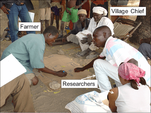
Figure 1 – Interpreters involved in community sketching at the village of Monko, Benin (F. Burini, 2010).
The sketch map is accomplished by leaving the participants at the assembly free to use a perspective or zenithal view and the use of abstract or figurative symbols distributed in a way which is an similar to reality, leaving out any pretence to accuracy and precision of distances: the data represented refers to quantitative and qualitative information gained from the knowledge and experience of the community which produces the map, and refers to the problem identified.
In this way semantics are produced which favour a perspective view and the use of symbols which are mainly figurative, and to which the toponyms transcribed in the local language are associated. These are icons that refer to knowledge which is symbolic, which give to the land socially recognisable values such as history and myth (sacred sites, places of foundation) or performative and carry a wealth of knowledge that can be divided into three categories: functional knowledge, aimed at intellectual knowledge and material practices for the identification of locations in which productive activities take place (agricultural and pastoral areas, hunting and fishing grounds and areas which are harvested); jurisdictional knowledge which give information regarding the social and territorial organisation of the local community (village boundaries, position of land, political and religious authorities); and security knowledge, aimed at optimising the use of resources and at guaranteeing their reproducibility (rested agricultural areas, unused forests) [18].
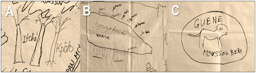
Figure 2 – Examples of icons which refer to symbolic, functional and jurisdictional knowledge (F. Burini, 2010).
Figure 2 shows three examples of symbols relating to symbolic, functional and jurisdictional knowledge. In the first (A), the icon, produced by local farmers from Fiafounfoun (Benin) of the Mokollé tribe, is made up of the figurative replacement for the baobab, accompanied by the toponym kpoto, and indicates the foundation site of the village, which subsequently became a sacred place; in the second (B), the symbol was produced by the Peul farmers of Kiwirkoye (Niger), and shows the pasture area and the resources for animals [19]; finally, in the third (C), the symbol produced by the advisors of the sovereign of the village of Guéné (Benin) is made up of the toponym Guéné, the lion that is the symbol of the sovereign, and refers to the seat of political power.
From these examples, it emerges that if studied through cartographic semiosis, community sketch maps become communicative systems rich in information featuring cultural values and knowledge of the community that produce them.
Digitalisation of community sketch map: syntax and pragmatics.
Sketch maps are not sufficient to guarantee that environmental protection takes into account information transmitted by village communities. Indeed, those running the project might have difficulties in interpreting such drawings, due to the high density of information represented, the scale used, and a graphical system that does not correspond to a topographic language. Therefore, it is useful to transform these drawings into digital maps. Those maps can in turn be taken into consideration during the implementation of environmental policies.
Community sketch maps are, as a consequence, digitally reprocessed (Gis applications, computer graphics systems, Gps, satellite and aerial images). Respecting the information and the graphical choices of the drawing in this process causes further constructive choices. Experimentation in this area integrates qualitative and quantitative data taken from community sketch maps in computerised systems, with the aim to guarantee three factors: accuracy of management of the data in the database; the return of information obtained in local contexts, putting it into a larger territorial context; and the use of a coding system which is able to be interpreted by parties who do not belong to the village community.
The resulting maps will subsequently be subjected to validation by the villagers, who will be asked to express their opinion on the accuracy and explanatory relevance of the information they previously supplied.
With regard to the construction system, information is geo-referenced, importing data from Gps and interpreting satellite and aerial images. Furthermore, additional information can be included through observation and inquiry. Therefore, during digital transposition, the researcher can compare information from a variety of contexts, as well as one document with another. The result is the creation of maps referring to the statute of the land, the distribution of the population, symbolic and productive activities, and other aspects, where different cultural perspectives and local knowledge and techniques become a symbiotic inter-cultural product.
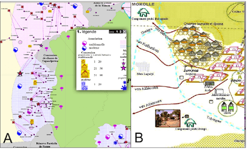
Figure 3 – Typology of data entered into knowledge community mapping systems at a regional (A) and local (B) scale. Source.
Figure 3, for example, shows details of two maps produced on a regional (A) and local (B) scale. The first map refers to aspects of tradition and modernity of villages on the edge of the W Regional Park. The second shows a plan of the village of Mokollé. In both cases, the data included refer to both information collected through community mapping (presence of sacred sites, presence of subsistence or speculative farming), as well as data collected from on the ground enquiry (statute of the land, presence of associations, type of authorisations, type of markets). With regard to the graphic transposition, the first case clearly shows the use of both figurative and abstract signs, while in the second, figurative signs are used exclusively.
In the production of these maps the researcher must take into account the communicative results created by the use of icons, that is the capacity of the map to create self-referencing messages which are able to carry a precise vision of the world produced through conjecture which, taking the place of reality, conditions activity in the territory (Casti, 2003b: 322-23).
With regard to the possibility of translating some guidelines for environmental cooperation such as those for participation and planning into cartographic tools for the implementation of territorial governance, we can now affirm that this can be made possible through effort and careful attention throughout each phase of map construction.
In reality, we are not referring to the simple production of drawings or participatory systems through the involvement of local parties, but to the mastery of the communicative results of such documents. To reach this goal, in the first instance, local communities must be involved in all phases of the process. Secondly, the data must refer to the knowledge and understanding of local populations. Finally, with regard to graphic transposition, the cartographic symbols must be figurative, providing for the use of perspective or three-dimensional views, in order to facilitate the comprehension of their meanings by parties from a variety of cultural contexts.
To conclude, if produced with the support of adequate interpretative tools, such as, in our case, cartographic semiosis and the Sigap strategy, community mapping is able to fill the cognitive gap that exists between local knowledge and technical know-how, avoiding the process of “marginalisation” reported by American geographers.
