Risks associated with natural hazards have been widely studied within social science, and numerous concepts have been developed to identify, describe, analyze, and quantify their risks for human societies (Pigeon, 2005). In the current context of global climatic change, numerous studies have been undertaken to assess specific risks linked to relative sea-level rise (rslr). In France, most of these works have been reviewed by Denis Lamarre (2008), who proposed that these risks were characterized by a high degree of uncertainty that made their analysis and prediction very difficult. For instance, common concepts such as the frequency-intensity pair may be irrelevant as there is no accurate knowledge of what the intensity of events might be, and scenarios about possible frequency are highly debatable. Climatic changes, over different time and spatial scales, have led to new areas in need of investigation: risk evaluation, adaptation, management, and mitigation.
Within this wider context, this paper reconsiders a specific risk: coastal retreat associated with rslr and loss of archaeological heritage. As coastal systems are highly sensitive to climatic changes, this calls into question coastal vulnerability analysis as associated with coastal hazards.
According to a brief review of recent works, the vulnerability of a coastline is defined in relation to the amount of anthropogenic features which are threatened by the predicted coastal changes (French, 2001; Ferreira et al., 2006; Alphar, 2008; Snoussi, 2008). In these works, coastal vulnerability is mapped by determining a buffer zone within which coastal processes damage anthropogenic features located along the coast. These damages are most often quantified using a cost-benefit approach (cba) (El-Raey, 1997; Carter, 1999; Williams et al., 2001; Nicholls, 2004; De Pippo et al., 2008). The cba can be broadly defined as a financial evaluation of costs and benefits linked to both coastal changes and different management strategies likely to cope with the predicted coastal evolution. Such an approach can only integrate the loss of non-economic, yet valuable objects with difficulty, and has been severely criticized for this very reason.
A comprehensive workshop was held in 1996 at Portsmouth University on behalf of a group of British conservation societies and science societies. The main results, published in Hooke 1998, compared various assessment policies. Some were based exclusively on economic settings (land or building market prices), while others integrated heritage issues and landscape changes by evaluating the resources they provided for tourism (“indirect cba approach”). These results, or recommendations, have been elaborated upon (e.g., Saengsupavanich et al., 2008) in recreational areas to evaluate beach landscape values. The combination of these two approaches (mapping of the spatial extent of the area likely to be affected by some damages, and quantification of the financial loss caused by the damages) provides a useful tool for coastal management. However, it does not take into account all of the complexity associated with the concept of vulnerability.
Joern Birkmann (2007) and Hans Martin Füssel (2007) have reviewed and analyzed various definitions of vulnerability as applied to social- and environmental-system risk assessments. They conclude that vulnerability encompasses a large range of different concepts depending on the focus of the study. A vulnerability evaluation entails addressing at least three different points: establishing the human-environmental system concerned by the analysis, defining the values of attributes exposed to a hazard, and assessing the potentially damaging influence of the hazard (Füssel, 2007). When analyzing these points, the degree of vulnerability appears to be closely related to the physical susceptibility of the system and its socioeconomic fragility (Birkmann, 2007). The notion of socioeconomic fragility begs a definition of the value associated with anthropogenic features and social uses, as well as their resilience.
Currently along the coast, anthropogenic objects that do not fit into a direct or indirect land-use or economic activity and that are non-touristic are not considered as adding vulnerability to the coast. This is because the definition of coastal vulnerability is often restricted to the methods previously defined. However, such objects are of great importance and they are highly threatened by coastal retreat.
There are coastal archaeological sites seated along retreating coastlines. The most famous of them, such as the standing stones of Carnac in Brittany, which attract visitors and create wealth, would be integrated into a cba approach. By contrast, coastal archaeological sites with no touristic interest, and which are of interest to scientists only, and composed, for instance, of prehistoric shell middens or burials, Gaulish salt workshops or villages, buildings of the Roman period, fish traps, etc., are never taken into consideration when assessing damages linked to coastal retreat. Such sites are not monumental remains; they do not attract visitors and they do not produce economic wealth. Nevertheless, they are of interest for coastal societies, for they represent a source of knowledge regarding the history of human activities, and their study enhances our understanding of the behavior of anthropogenic coastal systems. This last point can, in turn, improve our understanding of coastal hazard occurrence and risk assessment analysis.
This paper provides a new method to assess coastal vulnerability by mapping and integrating the risk of archaeological heritage loss. Results are discussed in order to analyze how the introduction of such new parameters could modify both management practices and perceptions of risk assessment. The study focuses on sandy beaches and weathered cliffs located along the coasts of the Rhuys Peninsula and Vilaine Bay, in Southern Brittany (see figures below). These sites were chosen because various databases concerning both the geomorphologic behavior of the coast and the locations of coastal heritage sites were available.
The Coastal Sites.
The southern coast of Brittany is subject to a wind climate dominated by westerly and southerly winds. At Belle-Île, located about thirty kilometers seaward of the sites, the strongest winds and storms come from the south and west (Pirazzoli et al., 2000; Pirazzoli et al., 2004 ; Tessier, 2006). Prevailing waves range from 0,5 to 2,5 meters with a period of 5 to 9 seconds. They mainly come from the northwest and west.
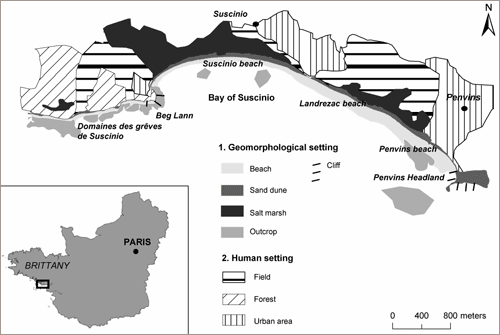 The sites are characterized by different geomorphologic settings. The first site is located in the Rhuys Peninsula and comprises a sandy beach-dune barrier system. It broadly extends from the Suscinio Banks domain to the Penvins Headland, which is composed of weathered, periglacial deposit cliffs not exceeding two meters in height. The barrier is built with heterogeneous sediments ranging from pebbles to fine sand. It is exposed to the South. There extends seaward a complex pattern of submarine rocks and skerries. The barrier is backed by wetlands. Human settlements are rare in this sector, except southwest of Suscinio and around Penvins. Beaches are used for recreational purposes during summer time.
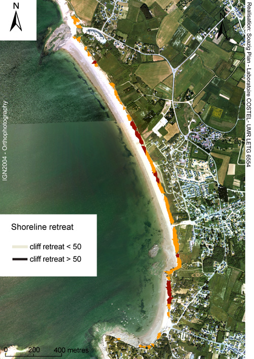
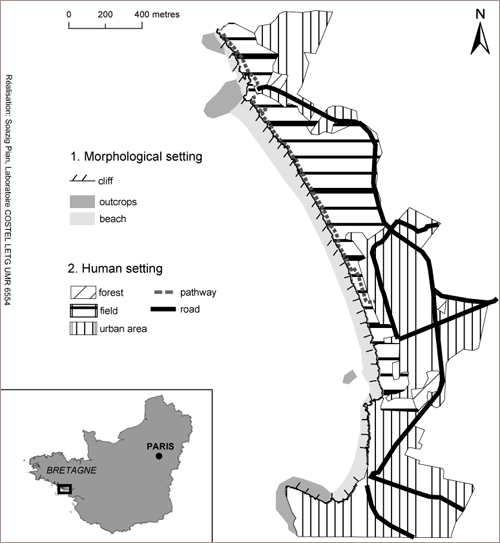 The second site is located to the east of Vilaine Bay, and is a weathered cliff system fronted by a sandy beach, fed to a large extent by the erosion of the cliffs. The coast is exposed to the prevailing western winds and waves. Maximum cliff height is around eight meters. Cliffs are cut into weathered rocks. The cliff face is divided into three lithostratigraphic units overlying a micaschist base, from base to top: soft clays with thick lateritic soil profiles, fluvial and tidal deposits (gravels, sands, and silts), and periglacial loess. The thickness of these different units varies along the cliff, leading to different rates of cliff retreat (Brault et al., 2001). The pressure exerted by human activity is great due to a footpath running all along the top of the cliffs and newly developed buildings backing it.
Assessing Coastal Retreat and Identifying Damages.
Our method is based on the principles and methodology developed by the Intergovernmental Panel on Climate Change (Ipcc-Czms, 1992) and discussed by Pier Vellingar and Richard J.T. Klein (1993). Four major steps were followed:
Assessment of current coastal changes and current erosive processes (step 1).
Mapping of coastal retreat in a context of rslr (step 2).
Identification of anthropogenic components likely to be damaged by coastal retreat, and evaluation of vulnerability profiles (step 3).
Classification of vulnerability profiles (step 4).
The third and fourth steps were run twice. No archaeological sites were included in the first run; they were however included in the second run.
Fieldwork and Air Photo Analysis (Step 1).
Depending on the geomorphologic setting of the sites, different measurements and observations were carried out between November 2006 and June 2008. In the Rhuys Peninsula about ten beach profiles were leveled between winter 2007 and summer 2008 at a monthly rate, from the foot of the dunes to the lower water level. They were used to compute beach slopes and then to integrate this parameter into a shoreline retreat model. Fieldwork also provided data about beach face behavior and front dune evolution on a short time scale. The front dune is the most mobile geomorphologic feature and records erosion evidence. Fieldwork carried out on the Pénestin Cliffs essentially aimed at identifying the main processes controlling cliff retreat. The site was visited at regular intervals in summer, and, as was previously discussed by Suzanne Durand and Yves Milon (1955), field observations show that cliff retreat is mainly driven by sub-aerial processes. Wave action is reduced to the mobilization of sediments delivered by cliff retreat.
The assessment of coastal erosive processes over a longer time period is based on analyses of aerial photographs. The use of aerial photographs in coastal studies has been widely discussed (Moore, 2000; Williams et al., 2001; Graham et al., 2003; Fletcher et al., 2003; Duffy et al., 2005). They allow the mapping of coastline movements using geomorphologic indicators, whose migration during the considered time interval is assumed to represent coastal evolution (Carter, 1999; Moore, 2000; Parker, 2003). On macro and meso coasts, foredune vegetation lines, foredune feet, or cliff tops are considered as relevant geomorphologic indicators (Battiau Queney et al., 2002; Robin, 2002; Ferreira et al., 2006; Anfuso et al., 2007; Kroon et al., 2008). For this paper, foredune-vegetation-line and cliff-top indicators were used.
Various time series of aerial photographs and three orthophotographs were available for this study, from 1952 to 2004. Coastline variation trends were measured and mapped by comparing documents from 1952 and 2004. The other time intervals were used only to check that these 52-year trends coincided with shorter time intervals. The table below summarizes the main characteristics for each of these photographs.
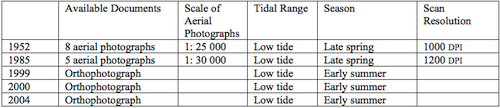 Main characteristics of the aerial photographs used.
The aerial photographs were scanned with a spatial resolution of 1200 dpi, geo-rectified, and set into mosaics. The foredune vegetation lines and cliff tops were plotted on each document as a poly-line. The dynamic behavior of the coastline was then determined by measuring the area between the two different poly-lines. The values of the error margins linked to the geo-rectification and digitization processes were extracted from the measured areas, and shoreline migration rates were computed from these data.
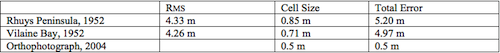 Margins of error determining the accuracy of plotted shoreline position in 1952 and 2004.
Modelling Shoreline Retreat in a Context of Rslr (Step 2).
Prediction of the coastal positioning process encompasses four sub-steps.
First, coastline migration rate measured from aerial photographs taken from 1952 to 2004 is extrapolated to 2100. This suggests that the coastline behavior observed between 1952 and 2004 reflects a general trend likely to continue in the near future. Such an assumption appears logical for coastal cliffs as long as they are made from homogenous rocks, like the Pénestin cliffs. It could be more questionable when it comes to beach-dune systems. However, previous works (Regnauld et al., 2004) have shown that the beach-dune system of Suscinio adopts a very regular behavior over time. Extrapolation over time would seem to be a relevant hypothesis. Therefore, to model setback lines, the simple equation of Ferreira et al. (2006) can be used, where t is the duration (in number of years) of the forecasted period and r the shoreline migration rate between 1952 and 2004 in meters:
S1 = t · r
In a second sub-step, rslr effects have to be added. Currently, most studies focus on shore-face and beach evolution (Liu, 1997; Kont et al., 2003; Ferreira et al., 2006; Snoussi et al., 2008), and are based on the rule from Bruun 1962, which presents a geometric model to forecast coastal retreat. However, this model has been the focus of severe criticism (List et al., 1997; Cooper et al., 2004). Serge Suanez, Bernard Fichaut, and Lenaïg Sparfel (2007), following Paul Durand and Hugues Heurtefeux (2006), put forward an alternative and easier method (S2). They took into account the rate of shoreline migration (r) in m-1, the value of sea level forecasted for 2100 (E21) in m, the annual value of twentieth-century sea level rise multiplied by the number of years in the prediction (E20) in m-1,and the slope of the beach expressed in % (P):
S2 = r [ ( E21 – E20 ) / P ]
Adding equations 1 and 2 leads to the following:
S2100 = S1 + S2 = t · r + r [ ( E21 – E20 ) / P ]
S2100 represents the value of coastline retreat taking into account past coastal changes and the additional water rise induced by the acceleration of the rhythm at which the sea level rises (Durand and Heurtefeux, 2006).
The third sub-step consists in adapting the equation to local environmental conditions. In a beach-dune environment the shoreline can both retreat, thereby moving landward, or advance, and thus move seaward. When the beach-dune system undergoes shoreline advance, rslr can reverse or slow down the coastal accretion trends. In order to cope with these different situations, the model has been rewritten as follows:
Sb = t · r +/– r [ ( E21 – E20 ) / P ]
where r is expressed as a negative value when the shoreline retreats and as a positive value when the coastline advances. For each accretional site, two scenarios were modeled: in case 1, the accretional trend is not reversed, while it is in case 2. Along the Pénestin Coast, with its cliff environment, the beach slope parameter was removed because it is not relevant for steep slopes and because all the cliffs have a quasi-vertical slope. As the weathered cliffs of Pénestin retreat at different rates, the coastline was divided into different sectors and a mean rate of shoreline migration was computed for each one. Thus, the shoreline position for cliff environment (Sc) was computed using the following equation:
Sc = t · r + r ( E21 – E20 )
The fourth sub-step is the calculation of storm wave effect. Numerous morpho-dynamic coastal studies (Forbes et al., 2004, Lozano et al., 2004; Houser et al., 2008; Frihy et al., 2008; Sedrati et al., 2008) have shown that substantial quantities of sediment are moved during storm conditions, leading to an important accumulation or erosive process on the coast. Paul D. Komar (1998) has established an equation to compute the wave setup parameter (n), which broadly refers to the piling-up of water against the shoreline (Masselink et al., 2003). In this equation, H and T represent the maximum wave height and its corresponding period in deep water, while tanß is the mean beach slope:
n = 0.36 g0.5 H0.5 T tanß
The wave setup parameter is then used to create a buffer zone in the landward direction around the shoreline position obtained with the previous equation for the beach-dune system of Suscinio. The extreme setback line associated with the 2100 shoreline position is thus computed by adding the results of the rewritten and last equations. For the cliff system, the influence of storm waves was ignored since cliff retreat is mainly controlled by sub-aerial processes, and the model does not consider the effect of wave attacks on the cliff base.
Identification of Anthropogenic Features (Step 3).
Anthropogenic components likely to be affected by coastline retreat were inventoried using the 2004 orthophotograph (Williams et al., 2001). They are footpaths, human settlements or developments, agricultural land, private properties, tourist resorts, car parks, and other infrastructure located within a 100-meter buffer zone around the current coastline’s position. These anthropogenic features influence the vulnerabilities of both coastal behavior and coastal heritage sites (López-Romero et al., 2007). They have been classified into two categories. Category A contains features that can neither be lost nor moved without a high cost for society or individuals (agricultural land and all private or public infrastructure). Category B includes anthropogenic components that can be more easily moved landward, such as footpaths or camping sites. Neither of these two categories includes heritage sites. These categories refer to different degrees of socio-economic fragility (Birkmann, 2007). The first category groups together anthropogenic features the destruction of which impedes the social and economic functioning of the coastal system by affecting social uses. It represents a high degree of fragility and cannot be easily moved. The second category refers to a lower degree of fragility and encompasses anthropogenic features with a higher degree of resilience; they can be shifted landward while still providing the same social amenities as when they were located close to the coast.
The next step takes into consideration the location of threatened coastal archaeological sites. Regarding site 1, the list of heritage sites was obtained from the Regional Archaeological Agency of Brittany (Ministry of Culture). Concerning site 2, the localization of coastal archaeological sites was conducted by us on the basis of formerly published data (Gauthier, 2006) and was then integrated into a geo-referenced database. For the purpose of this study, all coastal archaeological sites were considered as having the same scientific value, since their disappearance would lead to the loss of a source of knowledge. They cannot be moved without loss of scientific information. Thus, their resilience was considered to be very low and they were included in category A. This last point and its epistemological background will be further developed in the following section.
Evaluation of Coastal Vulnerability (Step 4).
To map coastal vulnerability, the forecasted coastline was displayed for each site on the 2004 orthophotograph. Then, a visual analysis was carried out to identify the nature of the anthropogenic features located between the coastline’s current position and the setback line defined for 2100. To determine the coast’s vulnerability, a qualitative grid associated with different degrees of vulnerability was established. Three degrees of coastal vulnerability were established. The first and higher degree was associated with the presence of anthropogenic features belonging to category A. An intermediate level of vulnerability was assigned to lands with category B features. The third and lowest degree of vulnerability was assigned when no anthropogenic feature was threatened.
The mapping process was carried out twice. During the first run, no archaeological heritage sites were taken into consideration. The risk of archaeological heritage loss or damage was added to the analysis of the second run, and then only sites located within a 100-meter buffer area from the shoreline were retained. This limit is in line with French law controlling human developments within a belt of 100 meters in a landward direction (Bécet and Rezenthel, 2004).
Mapping Vulnerability.
The main results are displayed below.
Shoreline Evolution Rate between 1952 and 2004.
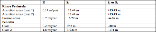
In the Rhuys Peninsula, beach-dune systems have been undergoing erosive processes during the last fifty years. The total eroded area reached 5158 m² between 1952 and 2004 with a mean rate of retreat of about 0.07 m/year (table below). This region also experienced some local coastline advance between 1952 and 2004, which indicates local sand accumulation. The accretion area reached 5930 m², with an annual mean rate of advance of around 0.14 m/yr (figure below).
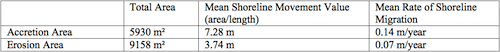 Mean values of shoreline retreat and advance, computed by taking into account the whole area of the two sites under study—site 1, Rhuys Peninsula.
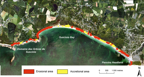 Coastline evolution between 1952 and 2004—Suscinio Bay.
In Pénestin, cliffs retreat at different rates according to both local human pressures and geomorphologic settings. These various rates were integrated into two main classes. The first class encompasses coastline retreat of less than 50 meters and represents around 87% of the coastline (figure below). The second class concerns a rapid coastline retreat exceeding 50 meters. For each class, a mean retreat rate was worked out and later used to forecast cliff retreat evolution.
 Coastline evolution between 1952 and 2004—Pénestin Cliff.
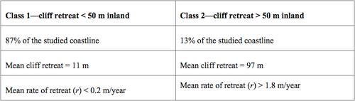 Main characteristics of shoreline movements between 1952 and 2004 at Pénestin.
Predicted Shoreline Position.
The shoreline position for 2100 was worked out for each site. Following Serge Suanez, Bernard Fichaut, and Lenaïg Sparfel (2007), the value for E20 was obtained by multiplying the value of annual coastline retreat taken from Paolo Antonio Pirazzoli (2000) by the number of years between 2009 and 2100, and the value for E21 was taken from Ipcc (2007): +0.13 m to +0.58 m. The last and higher value was used to determine extreme values.
 Shoreline position forecasted for 2100 by taking into account both current processes driven by shoreline evolution and the retreat due to rslr.
The equation for cliff environments was worked out for site 1 by taking into account the maximum significant wave height recorded at Belle-Ile and its associated period. The wave set-up parameter reached 3.56 m and was used in order to map the maximum reach of storm waves in 2100.
Coastal Vulnerability (Case 1).
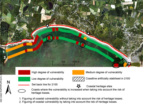
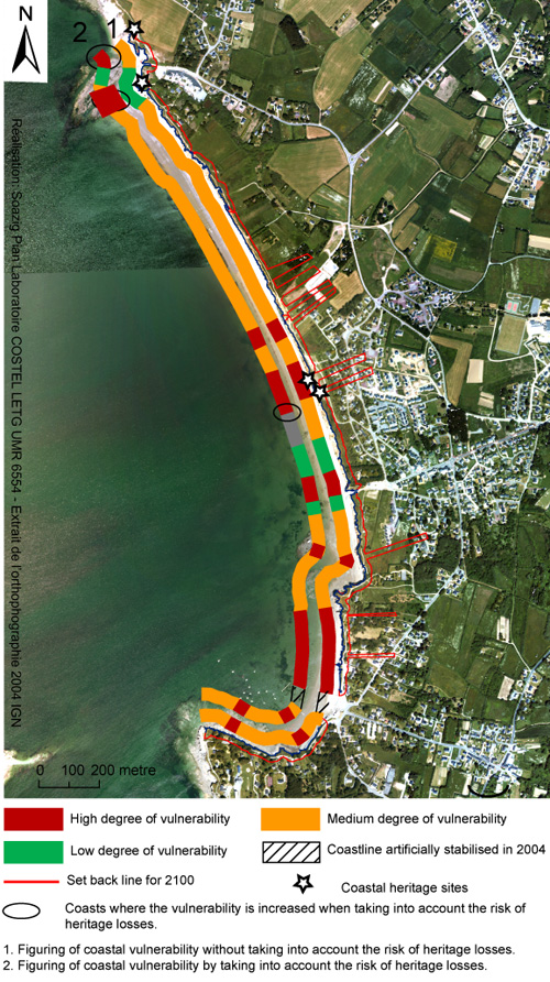
The first graphical band shows vulnerability without taking into account the risk of heritage loss. In the Rhuys Peninsula, where dune systems and wetlands remain free of human settlements, the vulnerability of the coast is not important. Few areas are concerned by a high degree of vulnerability, except the eastern part of the coastline where there is a denser spatial distribution of properties and settlements. On the other hand, the cliff system of Pénestin is much more settled and, as a consequence, experiences a higher degree of coastal vulnerability. Categories A and B are well represented, and all along the coast cliff retreat is threatening pathways, roads, agricultural land, and properties.
 Suscinio coastline vulnerability: the effect of coastal heritage site parameters.
 Penestin Cliffs vulnerability: the effect of coastal heritage site parameters.
Coastline Vulnerability Including the Risk of Cultural Heritage Loss (Case 2).
When taking into account heritage loss risk, the coastal-vulnerability map displays some distinctions. For both sites, this introduction of this new parameter has led to local increase in coastal vulnerability (figures above, second graphical band). Such phenomena are well represented in site 1, where human features are less present. As a consequence, a low degree of vulnerability was first assigned to the coastline. However, in two specific areas the presence of archaeological sites within the wetlands led to a slight increase in vulnerability. In the same way, the coast appears more vulnerable in three different local areas of the Pénestin cliff system.
Shifting the Point of View.
The method used for mapping coastline vulnerability due to shoreline retreat by integrating the risk of archeological loss remains qualitative. It could be further developed by integrating more variables related to anthropogenic factors, such as the effects of land-use or planning policies. However, such developments do not belong within the scope of this paper. Its main aim is essentially to show how the integration of usually poorly considered new anthropogenic variables can affect the definition of coastal vulnerability. Though this aim appears to be a simple one, it raises several epistemological questions specific to social science, even though the method does not integrate the whole range of coastal social practices.
The degree of vulnerability characterizing each given stretch of coastline is closely related to the definition of the anthropogenic components integrated into the analysis, as well as to the value assigned to them. When an economic approach is adopted, such as the cba approach, an “objective framework” can be used in order to assign a precise financial value to each item. Thus, the map of threatened components may become an effective tool to predict the cost of possible damages. However, objects not related to economics are left out of such an ”objective framework,” despite the fact that they constitute cultural or scientific resources. Coastal archeological sites are an example of such objects.
This paper argues that the scientific value of these famous or little-known sites could be of great importance for coastal studies since they provide data about the past occupation of the coastal fringe. They therefore improve our understanding of feedback between anthropogenic components and physical factors over a long time scale. In this way, the study of coastal archeological sites could increase knowledge about how highly anthropogenic coastal systems function, a mechanism that is still not fully understood (Nordstorm, 2000).
The first epistemic debate deals with this methodological assumption: erosion and destruction of heritage sites is a loss. Such a basic decision is based on the fact that these sites do contain some information and that this information has some scientific value. However, one can object that this last point is not at all obvious. On several occasions, when large storms were predicted during high spring tides, some emergency searches were quickly carried out on inter-tidal sites. Few artifacts were found, and some structures were mapped, but no “new” knowledge was obtained. The sites merely displayed what any other site of the same type would display. For the local authorities in charge of funding these searches, it appeared more as a loss of money than as the discovery of important scientific data. From discussions with local stakeholders, an important point repeatedly emerged: if a known coastal site is really important, it has already been studied and its relative scientific importance has already been assessed. From such a point of view (which is very likely to be true everywhere in France) a site that is known and has never been seriously studied is not an important one and is not going to provide exceptionally new data, material, or knowledge.
Another point of view is that, while most threatened sites will not reveal any new data, the importance of knowledge is not dependent upon uniqueness or exceptionality. This last point reveals a shift from an earth-sciences-centered point of view to a social-science-centered one. For the earth sciences, any coastal site displays a geomorphologic behavior that is linked to surrounding conditions (climate, geology, etc.), and any behavior means evolution and transformation during rslr. If several sites behave in the same way, there is no need to keep all of them in pristine condition, and they may be strongly modified and managed for any social use. If one site appears exceptional, many tools exist to protect it as a geological heritage site, geomorphosite, or landscape beacon. The site classé system may also apply. The politically minded choice would be to select one exceptional site to which protected status would be granted, and then to allow coastal management for other sites. Politicians follow exactly the scientific habits and methods of former geologists or geo-morphologists. The latter defined for instance, an “eponymous site” for such-or-such a brand of fossils, gems, or sediment, protected it, and exploited it everywhere else. As long as the original sample is kept in good condition, all other objects may be eliminated. This is the legacy of the cabinets de curiosités collections of the French-encyclopedia authors, who thought of science as the uniform application of single formulae valid everywhere.
This paper is based on a different scientific position and gives more importance to the social-science point-of-view. The value of a site is not granted because it is unique. The accrual of sites itself is considered scientific data. Scientific knowledge is not believed sufficient when extracted from one single site, nor is it considered valid or reliable data. The importance of different coastal heritage sites cannot be organized along a hierarchy since they all manifest the past presence of human activities. Each site was built and used by different people, and even tiny differences may be of some importance for paleo-social studies. This epistemic position leads us to consider that even a “minor” site, such as yet another salt oven among hundreds, is part of a collective land use, and is one element that scientists have to take into account when studying the place. This is an important point for the study of social science: important knowledge is not necessarily new knowledge. It may be merely previous knowledge in a new place. We might say that the importance of scientific knowledge for social archeology is much more site-dependant than for geology.
The mapping method presented in this paper allows one to take into account all coastal heritage sites. This scientific decision is based on social grounds which rely on subjective choices. This is the second epistemic issue. When taking into account objects with no financial value, such as common cultural heritage sites, the definition of coastal vulnerability becomes much more subjective, since it depends on the “value” the scientist attributes to these objects. Subjectivity influences the four steps of the coastline vulnerability mapping process. For instance, in the equation used to predict the 2100 coastline position, several parameters are biased by subjective choices. Because the only available wave data are from offshore, we have to hypothesize how the offshore waves will behave when they reach the coast. The beach slope is also a questionable piece of data. It is actually leveled with accurate equipment, and it represents an average calculated from two years of field surveys. However, we cannot accurately model how this slope is going to change when the sea level rises. There is also a very subjective choice made in assuming that the geological stratigraphy of Pénestin Cliffs is the same more than 100 meters inland as what we can observe today.
All of these points strongly echo Lamarre’s argument about the difficulties associated with the predictability of climate-change-related risks. In such a context, the measure of coastal vulnerability clearly appears to be related to researcher subjectivity in so far as the results depend on both the hypothesis and methods supporting the analysis. Differences displayed by the figures above highlight the fact that the location of a threatened archeological site along the coastline could locally increase coastal vulnerability. Such sites usually occupy very small areas, and consequently the vulnerability increases only on a very local scale.
However, when dealing with coastal management, it would make sense to consider the entire stretch of coastline characterized by an increase of coastal vulnerability induced by the presence of coastal archeological sites. This would help in keeping consistent coastal management plans. To protect some archeological sites from coastal retreat, managers will thus have to shield larger parts of sand dunes or cliffs from erosive processes. To be efficient, management will have to take into consideration the geomorphologic functioning of the coast to protect the whole feature. In a beach-dune environment, the sediment cell is recognized as the relevant spatial unit for coastal management (Cooper et al., 2001). Therefore, coastline management should include the whole sediment cell where the threatened archeological site is located. In cliff environments, management plans should focus on the cliff face’s geological structure in order to determine the homogeneous stretch lines likely to retreat at the same rate. It follows that the introduction of these new parameters could produce very different maps of coastal vulnerability. This in turn could lead to the need to protect stretches of coastline not yet considered vulnerable because the risk of heritage loss was not taken into account.
In addition, as most coastal-strip archeological remains have been discovered after the coast had retreated, it can be stated that any coastline retreat could, in theory, lead to the discovery of ‘new’ archeological sites, especially if we assume that Southern Brittany has possibly been settled as early as the late pleistocene period. Thus, the stretch of coastline that should be protected until coastal archeological sites have been studied could increase with time. This last point increases the uncertainties associated with coastal risk management and makes decision-making processes more complex: the definition of coastal vulnerability is evolving both over time and space according to the nature of the anthropogenic components integrated into the analysis (Regnauld et al., 1998).
This paper deals directly with these uncertainties and does not pretend to minimize them by using various scenarios and models. First of all, there is no reduction made in the multiplicity of sites in favor of the uniqueness of one perfect site. Coastal space is not thought as a collection of sites from which science should select the best one, but as a set of places between which ancient people have been traveling and working. Archeological sites are signs of a social territory as a whole and are not just artifacts to be sampled or collected. Archeological sites must be considered as social beacons and not merely as geological or geomorphologic objects. They cannot be moved from open-air sites to a museum without losing part of their significance. They cannot be dealt with according to the methods and habits of the earth sciences. They deserve to be thought of as tokens of a social dimension. Coastal retreat threatens an archaeological social territory, not a set of old stones. Consequently, coastal vulnerability to rslr retreat becomes relevant to social science, whatever the validity of the equated predictions is based upon. This implies that some social subjectivity has to be involved in the scientists’ decisions and this must be understood as a significant shift to a social-science type of scientific methodology: scientists do become actors in decision making. Conversely, there is also a need for a compensatory shift in favor of quantitative measures in order to increase objectivity and allow decisions to be taken by non-experts, as there is no reason why scientists should have more power in decision-making than other people. This is why actual protection issues have to be carefully grounded on material bases and on physical limits. The sediment-cell concept is the only available tool to divide the coastline into coherent units, and it is the only spatial basis for any management plan.
Coastal vulnerability assessment appears to be a real challenge and we can ask whether coastal-management bases are able to cope with it. We assume that some current coastal-management practices such as adaptive management could provide the theoretical basis for dealing with such a complex environment. Adaptive management is defined as “a systematic process for continually improving management policies practices by learning from the outcomes of operational programs” (Holling, 1978). In other words, adaptive management promotes the use of experimental approaches in order to reduce the negative impacts associated with uncertainties linked to environment management practices. To be efficient, such an approach should assess a wide range of different objectives dealing with environmental management, such as economic and social in addition to environmental ones. This implies making political choices that control decision-making processes (Gregory et al., 2006). However, experience has brought to light that adaptive management approaches can be used to develop a holistic coastal-management approach by favoring the integration of different stakeholders, and by taking into account environmental, social, and economic considerations. John Bennett (et al., 2005) provides an example of advantages associated with this sort of adaptive management system that is clearly related to the development of an integrated coastal zone management (iczm) (Dobbs, 2006). In the same way, Philippe Deboudt, Jean-Claude Dauvin, and Olivier Lozachmeur (2008) have pointed out that the evolution of the French institutional framework has aimed at encouraging the implementation of iczm since 2001. Similar evolutions have been recorded in the Uk, Portugal, and Norway (Ballinger and Lymbery, 2006; Calado et al., 2006; Edvarsen, 2006).
In Southern Brittany, the length of coastline threatened by coastal retreat tends to increase when coastal archaeological sites are taken into account while mapping coastal vulnerability. This simple observation leads to a more complex discussion dealing with subjectivity and uncertainty associated with coastal risk assessment in a context of sea level rise. This observation also concurs with the statement made by Lamarre (2008) highlighting new difficulties induced by global change in risk assessment, prediction, and management.
At the same time, numerous current coastal management practices, based on cba approaches, promote an economic approach to evaluate coastal vulnerability. Such approaches are definitely not able to encompass all the complexity and subjectivity associated with coastal vulnerability analyses. The social-science approach must be taken into account where the basis for spatial division is an objectively defined scientific concept while the value attributed to threatened objects is socially based and constructed. It becomes very difficult for scientists to explain that, on the one hand, they do have objective knowledge and that, on the other hand, they also need to implement very subjective assessment procedures for archaeological sites.
However, recent developments in the theoretical basis of coastal management, especially regarding adaptive management and icmz, are likely to provide relevant tools to cope with such a complex problem. They are likely to favor the integration of the risk of coastal archaeological loss into future coastal management plans. Moreover, when accurate data about coastal damage are needed, adaptive management practices do not impede the use of cba approaches, but provide a progressive framework for the integration of some uncertainties associated with coastal vulnerability analyses.
