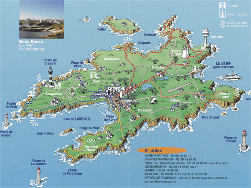
Within less than twenty-four hours, I have moved from Cairo, the capital city of Egypt, with its fifteen-million population, to the Ouessant island, with its less-than-a-thousand population. At the last moment before catching the boat sailing from Brest to Ouessant, I picked up a very impressive touristic map. On board, with a coffee and a cappuccino, I made contact with some French passengers who were coming from Marseille to have a holiday in that remote island. For a naïve Egyptian scientist like me, it was very surprising, as most of Egyptians have heard about the charming Marseille on the other shore of the Mediterranean, but absolutely nobody has ever heard of Ouessant.
 Taking into account my sudden switch from Cairo, where people move shoulder to shoulder, I found myself on this island with what might be called a ‘space shock.’
The initial impression during the first couple of days gave me a perception of a place which belongs to a paradise-like domain, where you meet with some kind of loneliness, sunshine, fresh wind, blue sea, wild rabbits and multicolored birds, organized gardens, and very satisfied people who usually look at you with a charming smile and hospitable ‘bonjouuur!’ This degree of space perception was definitely in consistence with the colorful touristic map showing the small village of Lampaul, lighthouses, windmills, sightseeing locations, wetland spots, and rocky coastline.
A week later, after intensive surveying of storm and tsunami proxies along the coastline and across the island, some new information had adjusted my early impressions.
First of all I wanted to understand if I had met with real native people of Ouessant. Most people here are outsiders, coming for tourism from different parts of France. I found very little about the cultural identity of the so-called local.
It seems to me that not only the ecological system of Ouessant is conserved as a national park but also that the native population on the island seems to be living in some sort of a ‘cultural reserve.’ Hence it was difficult to identify any kind of traditional costumes, local music, or cuisine; this may be understandable as the population number is very small.
In this context the touristic map has been prepared to illustrate the track routes along the island, making Ouessant just a ‘recreation’ target and giving very few opportunities to discover anything beyond the ‘natural identity’ of the place.
Some interesting local activities deserve to be mentioned in Ouessant, including the system of drainage and cultivation, scattered shepherding, cultivating the sea with weeds, old fishing techniques, lighthouses history, the deteriorating use of windmills, the wild life of birds and rabbits, sea fauna, etc. Moreover, the military history of Ouessant as a prominent fortress should be mentioned, as some sites belong to World War ii and before.
The touristic map also ignored to alarm the visitors to a very serious risk threatening the Northeastern coastline, e.g., the retreating cliffs. Most of the Northeastern coast of Ouessant is undergoing severe wave-cutting and cliff-sliding.
Many sectors of walking/biking tracks, shown on the touristic map, are actually vulnerable to hazard of collapsing and falling down. In a site near Porz Arland, the strength of wave erosion has penetrated so far inland that it has formed an explosive hole. A victim of this hole was a farming caterpillar, which collapsed some years ago. This huge machine still exists in the deep hole (more than twenty metres) and is an eyewitness to the severe wave-cutting and explosive wave dynamic—I cannot imagine that it was thrown there by the local owner, even though I would not bet that such things cannot happen.
It seems to me very important to revise any touristic map of Ouessant according to the actual research results about coastal retreat. On the one hand, the maps should delineate zones of risks as well as suitable spots for swimming and for sightseeing. On the other, in complement to the map there is a very good flow-chart model concerning how to achieved a balance between man and the natural system of Ouessant. This model is designed by French specialists under the patronage of the Unesco program ‘Man and Biosphere’ (Mab). It helps to understand that environmental behavior in Ouessant may be slightly different (and more complex) than what the map shows at first glance.
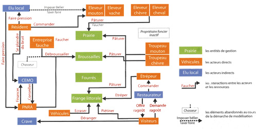 The flow-chart model is effectively very acute and takes into account the fragile environment of the island. The most important point in this model is the high importance given to soil protection and vegetation conservation. But, according to me, the model is too reasonable. It considers all local people as players and makes a game-like scenario in order to share the responsibilities among the interacting local people. Thinking of the way in which responsibilities are distributed in the Egyptian environment, which depends heavily on ‘vertical’ transfers of power and execution, I admired these ‘horizontal’ responsibility distributions.
This flow-chart model doesn’t take care of the coastline dynamic and the level of cliff-retreating that directly affect vegetation cover and soil stability, either. While this model focuses on the risks of soil destruction as a result of peat collection for cooking tourist cuisine in restaurants, it gives little attention to the direct effect of tourism activity on the long run, especially during the seasonal peaks. In that context, tourists walking/biking along the coastline are accelerating soil erosion and land collapsing. Ironically, these waking/biking tracks added to the shepherding along the coastline and to the numerous rabbit excavations on the top soil looks like the ‘triangle of misbalancing’ for this fragile environment, especially along the Northeastern sectors.
Nevertheless, as a naïve believer, I will ask my family to support my coffin with some road maps, two maps to wander easily in the Slovenian Alps and Slovakian Carpathian Moutains, and, most importantly, the new, revised map of Ouessant.
